


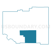
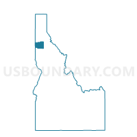
Emida Voting District, Benewah County, Idaho
About
Outline

Summary
| Unique Area Identifier | 563755 |
| Name | Emida Voting District |
| County | Benewah County |
| State | Idaho |
| Area (square miles) | 87.92 |
| Land Area (square miles) | 87.92 |
| Water Area (square miles) | 0.00 |
| % of Land Area | 100.00 |
| % of Water Area | 0.00 |
| Latitude of the Internal Point | 47.10896380 |
| Longtitude of the Internal Point | -116.62758590 |
Maps

Graphs
Select a template below for downloading or customizing gragh for Emida Voting District, Benewah County, Idaho


Neighbors
Neighoring Voting District (by Name) Neighboring Voting District on the Map
- Voting District 057022, Latah County, ID
- Voting District 057032, Latah County, ID
- Benewah Voting District, Benewah County, ID
- Fernwood Voting District, Benewah County, ID
- Santa Voting District, Benewah County, ID
- Tensed Voting District, Benewah County, ID
Top 10 Neighboring County Subdivision (by Population) Neighboring County Subdivision on the Map
- St. Maries CCD, Benewah County, ID (6,781)
- Potlatch CCD, Latah County, ID (3,817)
- Tensed CCD, Benewah County, ID (738)
Top 10 Neighboring Unified School District (by Population) Neighboring Unified School District on the Map
- St. Maries Joint School District 41, ID (6,788)
- Plummer-Worley Joint School District 44, ID (3,831)
- Potlatch School District 285, ID (3,281)
Top 10 Neighboring State Legislative District Lower Chamber (by Population) Neighboring State Legislative District Lower Chamber on the Map
Top 10 Neighboring State Legislative District Upper Chamber (by Population) Neighboring State Legislative District Upper Chamber on the Map
Top 10 Neighboring 111th Congressional District (by Population) Neighboring 111th Congressional District on the Map
Top 10 Neighboring Census Tract (by Population) Neighboring Census Tract on the Map
- Census Tract 9501, Benewah County, ID (4,749)
- Census Tract 9400, Benewah County, ID (4,536)
- Census Tract 55, Latah County, ID (3,817)